| |
 |
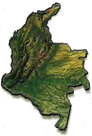
NATURAL REGIONS OF
COLOMBIA
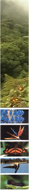
|
 NATURAL REGIONS OF
COLOMBIA NATURAL REGIONS OF
COLOMBIA
The Colombian
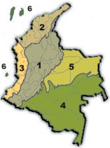
territory is divided into six main natural regions:
1 – The Andean region
2 – The Caribbean Coastal region or the
Atlantic Coastal region
3 – The Pacific Coastal region
4 – The Amazon region
5 – Los Llanos Orientales (Eastern Plains) or
the Orinoquia region
6
– The insular area
|
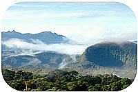
1 - The Andean Region
The Andes Cordillera (mountain range) enters
Colombia in the south-western part of the country and it is divided into
two chains: the Cordillera Occidental (Western mountain range) and the
Cordillera Central (Central mountain range). The Cordillera Central
divides into two branches at Macizo Colombiano (the Colombian Massif) or
Nudo de Almaguer, giving rise to the Cordillera Oriental (Eastern
mountain range). The so-called Cinturón de Fuego del
Pacífico (Pacific Belt of Fire), formed by numerous volcanoes, is
located in this region. The Galeras volcano, near the city of Pasto,
and the Nevado del Ruiz (also a volcano) are important for their recent
activity.
Description of the
Three Branches of the Andes Cordillera
|
| The
Cordillera Occidental (Western mountain range) With a length of
nearly 1,200 km, the Cordillera Occidental runs northwards through the
country from Nudo de los Pastos (the Pastos Massif) in Nariño
department, Southwestern Colombia, to Nudo de Paramillo (the Paramillo
Massif) in Cordoba department, situated in the northern region of the
country.
Highest Mountains: :
Cumbal Volcano, 4,764 metres high.
Chile Volcano, 4,748 m high.
The Azufral Volcano, 4,070 m high.
Farallones de Cali, from 200 to 4,280 m high.
Tatamá Hill, 4,200 m high.
Paramillo Massif or Paramillo of the
Sinú, from 100 to 3,960 m high.
Munchique Hill, 3,012 m high.
The Cordillera
Central (Central mountain range) runs from the Nudo de Almaguer
or Colombian Massif in Cauca department to the San Lucas mountain range
in Bolívar, Northern Colombia.
It is the highest cordillera in the country
with peaks over 5700 m high and has a length of more than 1,000 km.
Highest Mountains (Nevado =
snow-covered
mountain)
Nevado del Huila, 5,750 m high.
Nevado del Ruiz, 5,321 m high.
Nevado del Tolima, 5,216 m high.
Nevado de Santa Isabel, 5,150 m high.
Nevado del Cisne, 4,800 m high.
Puracé Volcano, 4,646 m high.
Cerro Negro, 4,470 m high.
Galeras Volcano, 4,276 m high.
Doña Juana Volcano, 4,250 m high.
The Santa Rosa de Osos Plateau, 2,640 m high.

|
The Cordillera Oriental (Eastern
mountain range) is the longest mountain range in the country with a
length of 1,200 km. This cordillera runs from the Nudo de Almaguer to
the Perija mountain range in La Guajira department (Northeast Colombia),
where it divides into two branches: The Motilones mountain range which
runs towards the north, and the Táchira mountain range which
crosses the border between Colombia and Venezuela.
Highest Mountains
Sierra nevada del Cocuy, 5,330 m high.
The Sumapaz moor, 3,820 m high.
The Pisba moor, 3,800 m high.
The Perijá mountain range, 3,750 m high.
The Choachí moor, 2,980 m high.
Plateaus
The savannah of Bogota, 2,600 m high, where the
city of Bogota lies.
The savannah of Ubaté, 2,570 m high.
The valley of Sogamoso, 2,570 m high.
|
Inter-Andean
Valleys
The Cauca River valley, situated
between the Cordillera Occidental and the Cordillera Central.
The Magdalena River valley, between the Cordillera
Central and the Cordillera Oriental.
The Atrato River valley which is found between the
Cordillera Occidental and the Pacific mountain range. |
2 - The Caribbean Region
Situated to the north of the Andean region, with
an area of 132,288 square kilometres, this region comprises the coastal
plain of the Caribbean seaboard and some separate mountainous zones.
Prominent in this area is the snow-covered
mountain range of the Sierra Nevada de Santa Marta, the highest in
Colombia. Its highest peaks are Simon Bolivar and Cristobal Colon which
reach up to 5,775 metres (18,947 feet) above sea level.
The departments of Atlántico,
Bolívar, Cesar, Córdoba, La Guajira, Magdalena and Sucre
lie in this region.
3 - The
Pacific Coast Region
The region comprises the coastal plains of the
Pacific seaboard to the west of the Cordillera Occidental. It stretches
from the Colombian border with Panama to the border with Ecuador and has
an area of 80,000 square kilometres. The Baudo mountain range, the
Pacific mountain range, the Darien and the Katios National Park lie in
the region. The Choco department and part of Valle del Cauca, Cauca and
Nariño departments are situated in this area.
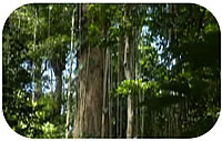
4 - The
Amazon Region
The Colombian Amazon region lies to the south of
the territory between the Guaviare and Amazon Rivers, the Cordillera
Oriental and Brazil. It has an area of 403,348 square kilometres. It is
an area of rainforest and comprises the departments of Amazonas,
Caquetá, Guainía, Putumayo and Vaupés. The
Amacayacu Park, the Cahuinari Park and the Nukak Nature Preserve are
known for their beauty and biodiversity.
|
5 - The
Orinoquia
(EASTERN PLAINS) REGION
It is a fairly flat territory
with low vegetation. It stretches from the skirts of the Cordillera
Oriental to the border with Venezuela and from the Arauca River to the
Guaviare River. It is an area of 310,000 square kilometres. The
Macarena mountain range, approximately 2,000 m high, is situated in this
region. The Arauca, Casanare, Meta, Vaupes and part of Guainia
departments lie on the Eastern Plains.
6 –
The Insular Area
The Caribbean insular area is
made up of small coastal islands and the islands of San Andres,
Providencia and Santa Catalina which are surrounded by sandbanks and
important cays.
The Pacific insular area covers
Malpelo and Gorgona islands.
|
|
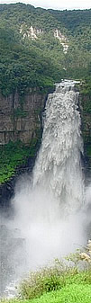
LAND ELEVATIONS (Sierra = mountain chain
- Serranía = mountainous region)
Besides the Andean region
described previously, the most important land elevations are:
Sierra Nevada de Santa
Marta
Location: The Caribbean Coastal plains. It extends
through the departments of Magdalena, Cesar and La Guajira
Elevation: 5,775 metres (18,947 feet) above the sea level.
Highest peak: Cristobal Colon followed by Simon Bolivar. It is the
highest snow-covered mountain mass in Colombia.
Area: 17,000 square kilometres.
Montes de
María or San Jacinto mountain chain
Location: Between Bolivar and Sucre departments on the
Caribbean Coastal plains.
Elevation: 810 metres
Serranía de la
Macuira
Location: La Guajira department.
Elevation: 810 metres.
Area: 250 square kilometres.
Serranía del
Darién
Location: Chocó department. Border region
between Colombia and Panama.
Elevation:1,910 metres in Tacurcuna Hill.
Serranía del
Baudó
Location: Chocó department, close to the
Pacific Ocean coast. It separates
the basins of the Baudó and Atrato Rivers. It runs parallel to
the coast.
Elevation: 1,810 metres
Serranía de La
Macarena
Location: Meta department, to the southeast of
the Cordillera Oriental
Elevation: About 2,000 metres.
Area: 625 square kilometres.
Serranía del
Perijá or Serranía de los Motilones in the southern
area.
Location: Northeastern Colombia. It serves as a
partial boundary with Venezuela between La Guajira and Norte de
Santander departments.
Elevation: 287 metres.
Southeastern elevations
Location: The Eastern Plains. Widespread hills such as
the Iguaje and Yambi low plateaus, and the Araracuara mountain range.
See TOPOGRAPHIC MAP
|
|
|